As part of the Postgraduate Research Placement Scheme, I was one of two placement holders involved with helping Professor Henry Chapman from the Department of Classics, Ancient History and Archaeology on his research, investigating the morphology and landscapes of Iron Age marsh-forts. This aims to investigate a type of archaeological site which is so far poorly understood.
Marsh-forts are commonly referred to as a sub-category of hill fort, but are characterised by their wetland settings. This research continues on from the investigation of Sutton Common in South Yorkshire, which was published in 2007. It aims to explore whether there is more to these sites than just their wetland landscapes, looking in particular at how their architecture relates to their surroundings.
In order to explore this topic, I was tasked with collecting data from a variety of sources for different sites and using Geographical Information Systems (GIS) to collate the data and produce interpretative plans showing their architecture and surrounding landscapes. In total I produced GIS datasets for nine of these sites. The data I collected included Ordnance Survey (OS) plans of standing earthworks, LiDAR data (produced from laser scanning of the ground surface to produce topographical maps which often show hidden details that are not visible on the ground), British Geological Survey (BGS) maps, aerial photography and published archaeological reports and excavation plans.
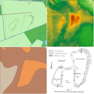
I then collated the data using GIS software and using my own knowledge of these sites, produced interpretative plans representing the key features of these sites.
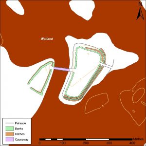
The models produced have already dramatically changed our understanding of these sites, showing variations within the category of marsh-forts which had hitherto been unidentified. As a postgraduate Archaeology student with a personal interest in later prehistory, it has been immensely rewarding to be involved in this research placement.
Working jointly on the project with Professor Henry Chapman as well as my co-placement holder, Jess Stevens, has been a unique and interesting experience. Working as part of a team on a project is different to the independent research I have previously done as part of my undergraduate and Master’s dissertations. It has provided an opportunity for the discussion of ideas that has really helped this project to come together. Working with Henry, I was able to develop my own skills and knowledge, particularly in the technical side of this work, but also in the way the sites can be interpreted etc. Meetings throughout the placement helped me to deal with any issues I encountered and gave me an understanding of how my work directly impacted the overall research project.
Overall, working on this project has been incredibly insightful and as well as giving me useful academic skills, it has encouraged me to look to further postgraduate study in the future.
Theo Reeves, MA Archaeology (Cultural Archaeology)