My postgraduate placement, split with Theo Reeves, involved investigating the architectural features of Iron Age Marsh forts with Professor Henry Chapman. Marsh forts are a distinct type of hillfort which are found in low-lying wetland contexts. These marsh-forts consist of a series of ditches and banks with associated causeways across the earthworks and surrounding wetland. The primary aim of the project was to identify, and then map, the Iron Age features of these sites.
To achieve this aim, I utilised geographic information system (GIS) software to create these digital maps of the sites. To identify these earthworks from existing evidence I initially used ordnance survey maps at a 1:1000 resolution to trace any mapped features into the GIS program. Where no earthworks were identified in the ordnance survey maps, I used various other sources including lidar, historical maps, aerial photography, excavation reports, geophysical data and geological data to map the sites.
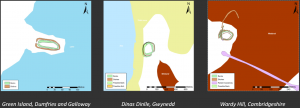
To answer the research aims set out by Professor Chapman, the most important features of these sites were the entrances to the marsh-forts and specifically which direction they faced in relation to the surrounding wetland. The peat deposits, alluvial deposits and bodies of water, such as pools and the sea, were mapped from the British Geological Society data and colour coded to distinguish from one another. The entrances proved the most difficult to locate and plan as the lack of excavational evidence surrounding these sites limits the possibility of interpretation.
The resulting plans produced of these sites proved highly interesting and contributed greatly to the overall interpretation of these sites. While some entrances appear to provide access to the marsh-fort interior at the most logical position within the landscape, others have entrances which seemingly go nowhere. These entrances have been theorised to possibly lead to causeways, trackways or as boat entrances but the evidence for these interpretations are highly limited suggesting that the possibility of a ritual entrance is more likely.
Throughout this project I gained valuable experience of conducting personal research and of gathering information from a wide range of sources. It was a refreshing experience to create work to be used in professional research and to create digital maps of a set format and standard of presentation suitable for publication. Regular meetings with Professor Chapman kept him up to date with my progress and findings and allowed any changes necessary to be made during the process rather than at the end. This process also allowed me to progress my skills within the GIS software as I was learning new functions and techniques for manipulating data. Overall this placement was a great opportunity to progress my skills and experience of professional research.
Jess Stevens, MRes Archaeology
Read Theo Reeves’ report into this project here.