In this case study, we hear from Guilin Luo, a PhD student in the School of Geography, who has been harnessing BEAR’s advanced computing resources to investigate how temperate forest soils respond to climatic change. By integrating high-resolution environmental monitoring data from the Birmingham Institute of Forest Research (BIFoR) site, and using workflows in R and Python, Guilin applies sophisticated multivariate time-series analysis and machine-learning approaches to understand soil moisture dynamics across different depths. This research not only informs future land-use management and vegetation modelling but also enhances our understanding of ecosystem resilience to extreme weather events.

My name is Guilin, a PhD student in the school of Geography. I am using BEAR to analyse long-term, high-resolution environmental datasets that capture interactions between meteorological drivers, soil conditions, and ecosystem responses. At the Birmingham Institute of Forest Research (BIFoR) site, we have established a continuous monitoring programme that records both atmospheric and subsurface variables. By integrating these complementary data streams, my research focuses on quantifying how temperate forest soils respond to ongoing climatic change. The aim is to generate evidence that can inform future land-use management, improve vegetation modelling, and support assessments of resilience to extreme weather events.
To transform the raw, high-frequency sensor outputs into analysis-ready data, I combine R and Python workflows. The pipeline (i) maps every observation into the correct spatial reference frame, (ii) applies rigorous quality-control filters to remove instrument noise and spurious spikes, and (iii) aggregates the cleaned series to scientifically meaningful temporal resolutions. This preprocessing stage is the foundation on which all subsequent statistical modelling is built.
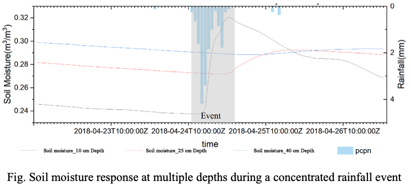
To show soil response to rainfall on an event basis, we present a figure illustrating how soil moisture varies across different depths during a concentrated rainfall event. The figure displays time-distribution curves of soil moisture at 10 cm, 25 cm, and 40 cm depths, with rainfall intensity overlaid for reference. These depth-specific responses reveal the vertical heterogeneity of soil hydraulic behaviour and underscore the importance of multi-depth monitoring in capturing the temporal dynamics of rainfall infiltration.
The computational demands of multivariate time-series analysis—particularly when experimenting with ensemble machine-learning models for outlier detection and gap-filling—are met by the University of Birmingham’s BlueBEAR high-performance computing cluster. BlueBEAR’s large memory nodes and parallel-processing capabilities shorten runtimes dramatically, enabling rapid iteration across model architectures and parameter spaces. Its visualisation nodes further streamline the creation of publication-quality graphics and interactive dashboards, accelerating insight generation and stakeholder communication.
Equally valuable has been the expertise of the BlueBEAR support team. Their training sessions and one-to-one guidance on advanced R libraries, workflow optimization and job-scheduler best practice have been instrumental in bringing this project from concept to execution. I am grateful for their patience and technical insight, which continue to enhance both the efficiency and the scientific robustness of my research.
We were delighted to learn how Guilin has taken full advantage of the services provided by Advanced Research Computing, especially in their innovative use of BEAR’s compute and storage resources. If you have a story of how BEAR has supported your own research, we would be very pleased to hear from you — please do get in touch with us at bearinfo@contacts.bham.ac.uk.